We received the following preliminary information about last evening's M5.8 earthquake from Lori Dengler, of the Redwood Coast Tsunami Working Group
Preliminary Information: March 8, 2020 M5.8 Mendocino Fault Earthquake Sequence
The earthquake
Here is the information I have at present. An earthquake occurred at 7:59 pm PDT*. The initial magnitude estimate (from the NTWS) was 6.0, the initial USGS estimate was 5.6, then modified to 5.9 and currently sits at a 5.8. It is not al all unusual for the magnitude estimates to vary in the first few hours after the earthquake. Initial estimates are based on fewer instruments and less detailed analyses than later ones.
The earthquake was located on the Mendocino fault, the transform plate boundary between the Gorda and Pacific plates. It was centered at a shallow depth on a right-lateral strike-slip fault, accommodating the relative motion between the spreading Gorda ridge and the Pacific plate. The published USGS depth (1.4 miles) is uncertain. It is difficult to constrain the depths for offshore earthquakes because of the absence of seismographs offshore. The Berkeley moment tensor depth is 5 miles. It is safe to say that it is shallow.
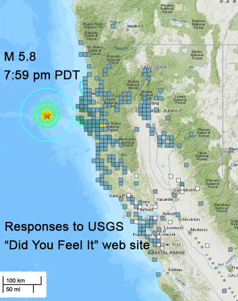
The earthquake was felt widely. At present there are over 2,700 felt reports to the USGS Did You Feel from Santa Cruz to Brookings and inland to Redding. Peak intensities are in the MMI 5 range, meaning a few items were reported knocked over. No significant damage has been reported.

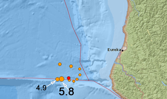
The earthquake was preceded by a M2.6 earthquake at 11:24 am centered about 7 miles east of the mainshock location. It may be considered a foreshock, although earthquakes of this magnitude are so frequent on the Mendocino fault, that it's difficult to demonstrate statistical significance. Eight aftershocks have been reported to date: a 2.5 at 9:10 pm, a 2.9 at 10:01 pm, a 2.5 at 11:12 pm, a 2.4 at11:29 pm, a 4.9 at 11:32 pm (all on 3/8), a 2.5 at 12:24 am, a 3.5 at 4:04 am, a 3.7 at 4:14 am and a 3.3 at 6:56 am on 3/9. The aftershocks appear to be located both on the Mendocino fault and in the adjacent area of the southern Gorda plate. This may change with more detailed location analysis. The largest aftershock to date, the 4.9 at 11:32 pm, was also felt by many. There are currently 377 Did You Feel It responses, from Albion in Mendocino County to Trinidad and inland to Salyer.

Tsunami
This earthquake was no large enough to pose a tsunami threat. The National Tsunami Warning Center issued a tsunami information statement three minutes after the earthquake that a tsunami was not expected. NTWC also sent a 'no tsunami expected' statement after the 4.9.
Continued aftershocks
The USGS sent out an aftershock probability statement that the chances of more aftershocks in the magnitude 3 range in the next week is 65%, and the chance of a 5 or larger aftershock is 1%. There is always a small but real chance that a larger magnitude earthquake is possible, either on the Mendocino fault or in the Gorda plate.
Geologic context
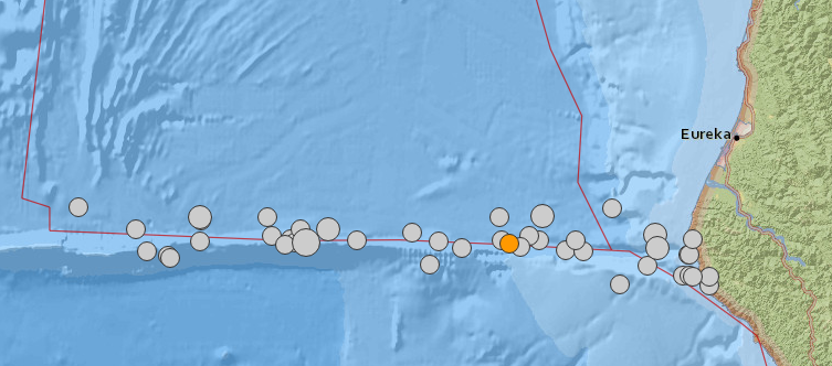
The Mendocino fault is arguably the most active fault in California. Since 1980, 33 earthquakes of magnitude 5 or larger have been recorded on or near the fault (omitting the Mendocino triple junction area), including three in the magnitude 6 range and a magnitude 7. There is nothing unusual about the current sequence and nothing to suggest that it makes other earthquakes in our area either more or less likely. The caveat is always that we are the single most seismically region of the State and a major earthquake could occur at any time.

M ≥5 earthquakes on/near the Mendocino fault since 1980
Additional considerations
- ShakeAlert and MyShake were not triggered by this earthquake. The reason is because the current notification boundary limit is at 126° West and the initial EEW location was 126.16°. I am in discussions with the ShakeAlert team to see if this can be changed. Offshore earthquakes are problematic in the absence of ocean bottom instruments because the initial location errors can be large in the few seconds that earthquake early warning requires to send out reliable messages.
- I have not heard if anyone on the coast self-evacuated based on the shaking. This is what many of us would consider a 'tweener,' mild shaking for a moderate amount of time. Here is where having the ability to receive text or twitter messages directly from the NTWC can really help. For tweeners - when in doubt drill it out. Start the process of evacuating. The 'no tsunami statement' from the NTWC was issued in 3 minutes and as soon as you receive it, you can relax and call off your evacuation.
- This is a good reminder that we live in earthquake country and that the next earthquake could be larger and/or closer to shore and cause significant to major damage. Know what to do when the ground shakes (DROP, COVER, and HOLD ON), know if you are in a tsunami zone, know how to evacuate, and have supplies (food, water, medications etc) to last you at least two weeks.